
Land Survey, Utility Mapping & Thermal Surveys A Complete View Above and Below the Surface
Understanding land requires more than surface-level observation. Critical systems often exist below ground or outside the visible spectrum, creating risk when they are undocumented or misunderstood.
Hydronos Corporation provides an integrated approach by combining aerial land surveys, utility mapping, and advanced thermal imaging to deliver clear, actionable insight for property owners, developers, utilities, and municipalities.
Aerial Land Surveys: Precision From Above
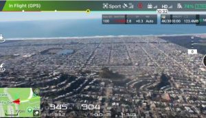
Drone-based land surveys allow rapid, non-invasive documentation of site conditions. High-resolution aerial imagery and mapping tools capture property layout, topography, drainage patterns, access routes, easements, and existing surface features without disturbing the land.
Utility Mapping: Understanding What Lies Beneath
Unknown utilities present one of the highest risks during development or excavation. Hydronos performs systematic utility mapping to identify water, sewer, storm, gas, electrical, communication, and private utility infrastructure. This documentation helps reduce risk, prevent utility strikes, and support informed planning decisions.
Thermal Surveys: Detecting the Invisible
Thermal imaging adds a diagnostic layer that reveals anomalies not visible to the naked eye. Infrared surveys can identify subsurface moisture migration, leaking underground lines, abnormal heat signatures, insulation deficiencies, and system inefficiencies before surface damage occurs, supporting precise drone leak detections.
An Integrated Data-Driven Approach
By merging aerial survey data, mapped utilities, and thermal imagery, Hydronos delivers a unified view of the property. This approach provides clarity, improves accuracy, and eliminates fragmented inspections.
Applications Across Industries
These services support land acquisition due diligence, pre-construction planning, municipal infrastructure assessment, water and utility district surveys, agricultural operations, and large residential or commercial properties, including opportunities for commercial drone leak detection – Northern California through Nevada where precise verification is required.
See the Land. Understand the Infrastructure. Plan With Confidence
Hydronos Corporation delivers comprehensive visibility into both surface and subsurface conditions, enabling smarter decisions, reduced risk, and long-term confidence in every project.